More severe storms on the way
Published 10:30 pm Monday, June 7, 2010

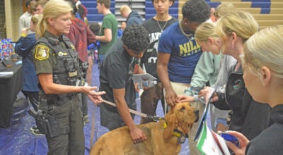
Berrien County was hit by a pair of tornadoes Saturday night, one of which left this home damaged along Cleveland Avenue near Stevensville. The National Weather Service said that EF1 and EF2 tornados caused widespread damage in the Baroda area. (Daily Star photo/SCOTT NOVAK)
By JESSICA SIEFF
Niles Daily Star
Officials throughout Berrien County are still busy with the cleanup from this weekend’s storms, and according to the National Weather Service, more severe storms may be on the way soon.
Michael Lewis, a meteorologist with the National Weather Service’s North Webster Indiana office, which covers northern Indiana and southwestern Michigan, said a warm front carrying significant moisture is expected to move through the area as soon as late today.
“So we have the potential of severe weather moving in,” Lewis said.
A total of eight tornadoes caused significant damage throughout the region as part of a line of storms that hit Michiana late Saturday night.
A preliminary report released by the national weather service on Monday stated four of those tornadoes hit in Michigan, two in Berrien County, one in Cass County and another in St. Joseph.
Three tornadoes hit in Indiana and another in Ohio.
Though Lewis stresses the importance in people being prepared for the dangers posed by tornadoes – he reiterates the importance of understanding the severe danger posed by severe thunderstorms.
“We had eight tornadoes in the Ohio, Michigan and Indiana areas,” he said. “But there was also a large amount of wind damage that was not associated with tornadoes.
“Severe thunderstorms can produce winds in excess of 70 to 80 miles per hour,” he said, “as there were with these storms.”
Lewis said the National Weather Service had three specialized teams out in each state affected by the weekend’s weather investigating damage.
“It’s weather CSI,” he said. “We start looking at the damage that occurred,” indicators such as “the level of destruction” to structures and trees.
Through that kind of investigation, Lewis said weather specialists can “get a feel for whether we had circulation or rotation” evidence of a tornado or whether the damage came from strong push, as with strong winds.
Lewis said last weekend’s weather was a mixture of the “necessary ingredients” to produce tornadoes, combined with strong, damaging winds wreaking havoc where tornadoes didn’t.
Brian Berndt, an engineer manager with the Berrien County Road Commission, said crews will be out cleaning up debris as a result of the weekend’s storms “probably for the next several days.”
Lewis says residents should view severe thunderstorm warnings as seriously as a tornado warning.
“It is a serious situation,” he said. “People need to be aware.”